
By Carol Ann McCormick,
Curatrix of the University of North Carolina at Chapel Hill Herbarium (NCU)
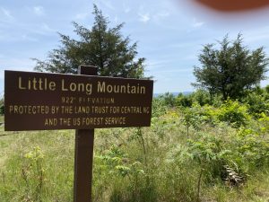
On a rather warm Sunday in May, 2020 my husband and I decided to venture to a new place to hike. We got an early start as our destination was Uwharrie National Forest in Montgomery County, a drive of about 75 minutes. The segment of the Uwharrie Trail we targeted starts at Flint Hill Road (SR 1306), near the confluence of Barnes Creek and Poison Fork, east of the village of Ophir. The trail follows a long ridge then crosses Poison Fork and climbs to the summit of Little Long Mountain at about 925 feet (282 m). Mark carried our lunch and water while I carried a plant identification book and mobile phone to make iNaturalist observations along the way. The trip was so rewarding that we’ve returned twice since that first hike.
Uwharrie National Forest’s 52,000 acres are in Davidson, Randolph, and Montgomery Counties.1 The Uwharrie Mountains “formed approximately 500 million years ago by accretion along the Gondwanan tectonic plate. They are thought to have once peaked at some 20,000 feet, before eroding to a maximum of just over 1,100 feet. The range’s high point is High Rock Mountain (1,188 feet / 362 m), in southwestern Davidson County.”2
The Uwharries are rich in human history. On my “to do” list is a visit to the Town Creek Indian Mound, a North Carolina State Historic Site located just south of Uwharrie National Forest. “During Late Woodland times, the cultures located between the Uwharrie Mountains and the border between North and South Carolina did not participate in the Piedmont Village Tradition. They were influenced by a very different cultural tradition called South Appalachian Mississippian. Between A.D. 1000 and 1400, Mississippian-influenced societies developed from the coast of Georgia to the mountains of North Carolina. Known archaeologically as Etowah, Wilbanks, Savannah, Pisgah, Irene, and Pee Dee, these politically complex cultures built mounds for their elite, participated in an elaborate ceremonialism, and sometimes ruled over large territories. In the southern North Carolina Piedmont, the clearest expression of South Appalachian Mississippian tradition is the Pee Dee culture. And the most obvious archaeological site relating to the Pee Dee culture is the Town Creek site, located on the Little River in Montgomery County. The people who lived at the Town Creek site during its heyday have been referred to as the “Pee Dee Indians” and their distinctive lifestyle, the “Pee Dee Culture.” Excavations revealed that the mound at Town Creek was constructed over an early rectangular structure that has been described as an earth lodge. Individual posts
set in holes formed the structure’s walls. Earth was then piled in an embankment around the walls and over the roof to create the “earth lodge.” Eventually this structure collapsed. Its remains and the surrounding area were covered, creating a low earthen mound that served as a platform upon which a temple or town house was erected. That structure ultimately burned. Its charred remains were also covered by a thick layer of soil, which served to enlarge and heighten the original mound. A second structure, identical to the first, was built atop the new mound. The mound at Town Creek faced a large plaza or public area where public meetings and ceremonial activities took place. Several structures, including some that served as burial or mortuary houses, were constructed around the edge of the plaza. The mound, plaza, and habitation zone were enclosed by a stockade made of closely set posts. Evidence of five episodes of stockade building has been found… Although not visible like the mound, equally impressive is the large number of human burials at Town Creek. A total of 563 burials are thought to be associated with the Pee Dee culture… A few of the Pee Dee burials were richly adorned with a variety of exotic artifacts made from copper imported from the Great Lakes area and shells from the coast. Copper artifacts include copper-covered wooden ear spools and rattles, pendants, sheets of copper, and a copper ax. Beads, gorgets, and pins were fashioned from conch shell… Archaeologists now believe that the fourteenth century saw the decline of many South Appalachian Mississippian centers like Irene and Town Creek. As the temple mounds were abandoned, burial practices changed to reflect a more egalitarian society. The shift from government by an elite to government by public consensus also is seen in the increased use of large public council houses, rather than priestly temples atop mounds. In the Savannah River Valley this decline in chiefly power is viewed, at least in part, as a consequence of prolonged drought conditions which caused a significant decline in agricultural production. The large number of burials at Town Creek may mean that the Pee Dee Indians faced a similar fate.”3
Abandoned mines are another visible legacy of human activity in the Uwharries. “In the early decades of the 1800s, the southern Piedmont’s gold mines attracted prospectors, investors, and miners. Tar Heel gold had first been found in 1799 on John Reed’s farm in Cabarrus County, several miles west of the Uwharrie Mountains. A lot of gold was recovered from the Reed Gold Mine, making Reed a wealthy man. Gold fever set in, as others tried to make their fortunes through mining. North Carolina experienced a gold rush in the 1820s and 1830s, becoming the nation’s largest producer of gold before the great California gold rush of 1849. By the 1830s, gold
prospectors and miners had moved into the Uwharrie Mountain region, searching the hills and panning the streams. Companies formed to finance mining operations. At least 15 mines, including the Russell Mine, opened in the Uwharries before the Civil War. These included placer mines, where pressurized water was used to wash gold from hillsides; shaft mines dug into hillsides; and large, open pit mines. Later in the century, miners even used dredges (machines that remove earth) to search the sands of the Uwharrie River. The Russell Mine was one of the largest gold mines in the Uwharries. Located in northern Montgomery County, it is near a crossroads aptly named El Dorado for the mythical city of gold that early Spanish explorers searched for. Despite the hard work of many miners and the support of a well-financed mining company, the Russell Mine—like other mines in the Uwharrie Mountains—proved to be only somewhat successful. Though the mine operated off and on into the late 1800s, the gold-bearing rock strata eventually played out. The mine had to close. The amount of gold present in the hard rock was simply not enough to make mining profitable, long-term. Several other older gold mines in the Uwharries survived into the early 1900s, and newer mines opened in the area in the late 1800s and early 1900s. There even have been attempts to restart some mines within the last 50 years. However, few people have struck it rich mining gold in the Uwharries, and none of the mines operate today. The clanging of ore crushers and mining tools no longer resounds through the forests of the Uwharries. But prospecting pits, open mines, and the ruins of mining operations can be found in many places.”4
The trail to Little Long Mountain starts with a relatively steep (but thankfully brief) climb to the top of a ridge along the east side of Poison Fork. It was a pleasant walk through a mixed hardwood forest and I stopped to collect a portion of bigleaf snowbell (Styrax grandifolius Ait.) as the only other specimen from Montgomery County in the herbarium had been collected by Elizabeth F. Wells in 1970 for her masters thesis, “A Vascular Flora of the Uwharrie Wildlife Management Area, Montgomery County, North Carolina.” As the trail began a gentle descent to Poison Creek Catesby’s trillium (Trillium catesbyi) in full bloom became even more numerous, and we
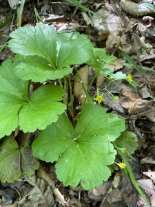
noted a wild ginger that looked like Hexastylis minor…but not quite. I collected that plant, and I am embarrassed to admit that it is still in a plant press, awaiting identification! A few steps farther, and we stopped to examine a plant which I suspected was southern barren-strawberry (Waldsteinia doniana, or in some books Geum doniana or Waldsteinia fragarioides). A quick check of images of herbarium specimens confirmed my ID, and I collected one plant for an herbarium specimen as it had never been documented from Montgomery County.
The trail descended to Poison Fork, and as we removed our shoes and socks to wade across, I pondered the name of the creek. Was it a corruption of Poisson — “fish” in French? Perhaps a resident along the creek made a toxic batch of moonshine which poisoned his neighbors? Perhaps the creek was “poisoned” for a time by mining activities in the 1800s? I was relieved to reach the far side of the creek with my feet intact and no ill effects from the brief dip into Poison Fork.
As the trail paralleled Poison Fork and we found primrose-leaf violet (Viola primulifolia) and black cohosh (Actaea racemosa) in bloom, though the umbrella magnolia (Magnolia tripetala) had already finished blooming. When I do this hike again, I will have to collect a specimen of Canadian lousewort (Pedicularis canadensis), as it has been collected only once in Montgomery County (by Peter Edward Bostick in 1962).
When the trail diverged from Poison Fork it slowly climbed into drier woods, then climbed at a steeper grade ascending Little Long Mountain. We were very surprised to find flatrocks on both sides of the trail — none of the trail resources we’d consulted mentioned this feature. As the plants found on flatrocks are among my favorites, we departed from the trail and carefully explored the rocks.
Many of the plants which live on flatrocks are diminutive — so stepping carefully is important. I had my eyes open for quill fameflower
(Phemeranthus teretifolius) and was quickly rewarded with a few plants, alas none in bloom. A quick check of sernecportal.org, an online catalog of herbarium specimens, revealed that quill fameflower had been collected twice before in Montgomery County. The most recent collection was at Badin Dam in 1978 by James F. Matthews of University of North Carolina at Charlotte. I found the earlier record even more interesting, as it was collected by John Simcox Holmes (1868-1958), North Carolina’s first state forester, in 1917 very close to where Mark and I had started our hike, “Rock cliff, Barnes Creek, Ophir Township.”
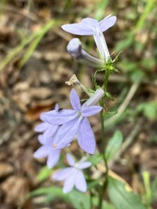
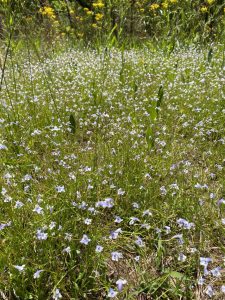
The highlight of the day was finding thousands of flatrock pimpernel (Lindernia monticola) in bloom on the flatrocks. “This species has
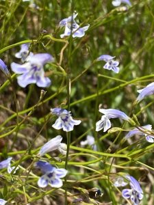
a very restricted habitat, in terms of acreage on the landscape. It is essentially limited to thin soil around the margins of granitic flatrocks, or granitic domes — but normally where there is some seepage on the rocks. Thus, it is a “semi-wetland” species, mostly in damp areas, often in moss, on these smooth or rounded rock surfaces,” according to Bruce Sorrie and Harry LeGrand, editors of NC-Biodiversity.com. “Flatrock Pimpernel is] widely scattered over the Piedmont, though essentially restricted to areas of granitic exposures; widely scattered in the southern Mountains. Does not occur in the central or northern Mountains, nor in the Coastal Plain. This is a Southern species, ranging north to northern NC, and south to northern FL and west to AL. It does not quite range into VA or TN, though it is found in counties that border them.”5 Flatrock pimpernel had not been documented from Montgomery County, so our collection was a county record.
The flatrocks on Little Long Mountain were home to another county record, elliptical rushfoil (Croton willdenowii), “a diminutive, very slender plant that nonetheless has a certain charm, with its narrow, silvery leaves (whitish beneath) and stem and tiny red-brown spots (at the center of each stellate hair),” according to Bruce Sorrie and Harry LeGrand.6
By this time, lunch was calling to us, so we continued to the summit and found the Eagle’s Nest shelter which was built by Boy Scouts in 2015.7 I highly recommend you use the shelter or its benches as lounging on the ground will result in an epic case of chigger bites!
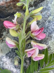
As we ate lunch, we enjoyed the panoramic view to the west and south — Little Long Mountain’s summit is one of the few in the Uwharries with such an expansive view. After lunch we turned our attention to the plants growing at the summit: goat’s rue (Tephrosia virginiana), pineweed (Hypericum gentianoides), wild bergamot (Monarda fistulosa), butterfly weed (Asclepias tuberosa), fragrant sumac (Rhus aromatica), New Jersey tea (Ceanothus americanus), and southeastern pricklypear (Opuntia mesacantha or Opuntia humifusa in older books).
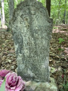
As we descended Little Long Mountain, we met another hiker who asked if we’d visited the “grave of the little girl.” He assured us that it was not far from the main trail, so we added that spur to our hike. After another refreshing dip in Poison Fork, we followed a trail upstream and found the grave of Dania Woodell.
Dania was born on 11 November, 1901, the daughter of Martitia Wright Woodell (1857-1943) and James Allen Woodell (1860-1918).8 She died at age 10 on 19 December, 1911, and is buried on a slope above Poison Fork. “In the very early 20th century, a preacher came to Poison Fork Creek and built a rudimentary shelter for the attendees of his regular sermons. More and more churchgoers began to gather here, and plans were made to build a church on the site. During this time, ten-year-old Dania Woodell died and was buried close to Poison Fork on the assumption that hers would be the first grave in a new church graveyard. However, for reasons unknown, the church was never built, and now young Dania’s grave stands all alone in the deep woods along Poison Fork.”9 While some might find Dania’s grave lonely, she is visited by many hikers and I find it a peaceful resting place.
If you’d like to visit Dania’s grave, pan for gold as you wade across Poison Fork, enjoy the view from the summit of Little Long Mountain,
and of course explore the flora of the Uwharries, keep an eye on the “Learn” portion of the NCBG website. I am planning a NCBG field trip to Little Long Mountain in May 2022, but that plan may need to change! According to Andy Walker, botanist with the Uwharrie National Forest, “There is a possibility that the Little Long Mountain area may be burned before May. We have a Uwharrie staff meeting in January 2022, and if the fire guys are on I’ll find out what they are planning for the next couple of months. This would be a cooperative burn, carried out with North Carolina Forest Service, and would extend beyond the Forest Service boundary to include some Three Rivers Land Trust property and maybe even some Plant Conservation Program property. If the area does get burned close to the time of the field trip, I could always suggest some alternative destinations. Other basic glades, or even Piedmont boggy streamheads might be nice alternatives at that time of year.” While a prescribed fire may interfere with a field trip in May, it would certainly be good for the native plants on Little Long Mountain!
SOURCES:
- United States Department of Agriculture Forest Service. “Uwharrie National Forest” https://www.fs.usda.gov/recarea/nfsnc/recarea/?recid=48934 accessed on 3 January 2022.
- Wikipedia contributors. “Uwharrie Mountains.” Wikipedia, The Free Encyclopedia. Wikipedia, The Free Encyclopedia, 4 Nov. 2021. Web. 31 Dec. 2021
- North Carolina Historic Sites, “Pee Dee Culture” (Excerpted from Time before History: The Archaeology of North Carolina, by H. Trawick Ward and R. P. Stephen Davis Jr., University of North Carolina Press, 1999.) https://historicsites.nc.gov/all-sites/town-creek-indian-mound/history/town-creek-and-indian-culture/pee-dee-culture accessed on 3 January 2022.
- Robinson, Kenneth W. 2008. Gold Mining in the Uwharries. Tar Heel Junior Historian Association by the North Carolina Museum of History. https://www.ncpedia.org/industry/gold-uwharries accessed on 3 January 2022.
- Account for Piedmont False-pimpernel – Lindernia monticola Muhlenberg ex Nuttal. https://auth1.dpr.ncparks.gov/flora/plant_list.php. accessed on 2 January 2022.
- Account for Elliptical Rushfoil – Croton willdenowii G. L. Webster. https://auth1.dpr.ncparks.gov/flora/plant_list.php. accessed on 2 January 2022.
- Weemhoff, Dan. 2016. Uwharrie National Forest – Little Long Mountain. dwhike’s Adventures. https://www.dwhike.com/Hikes-in-the-South/North-Carolina-Hikes/North-Carolina-National-Parks/Little-Long-Mountain-Uwharrie-NC/ accessed on 2 January 2022.
-
Find a Grave, database and images (https://www.findagrave.com/memorial/42681322/dania-l-woodell : accessed 02 January 2022), memorial page for Dania L Woodell (11 Nov 1901–19 Dec 1911), Find a Grave Memorial ID 42681322, citing Woodell, Uwharrie, Montgomery County, North Carolina, USA ; Maintained by BlackCloud (contributor 47187261) .
- Rainey, Stephen Mark. 2020. Ghosts of Dark Mountain. https://stephenmarkrainey.blogspot.com/2020/05/ghosts-of-dark-mountain.html accessed on 2 January 2022
All photos by Mark Peifer or Carol Ann McCormick